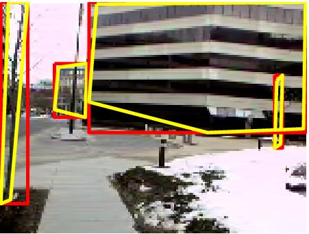
# PASCAL Annotation Version 1.00

Image filename : "MIT/PNGImages/seq_feb24_outdoors5/01290.png"
Image size (X x Y x C) : 160 x 120 x 3
Database : "The MIT-CSAIL Database of Objects and Scenes"
Objects with ground truth : 4 { "PAStree" "PAStree" "PASbuilding" "PASbuildingWhole" }

# Note that there might be other objects in the image
# for which ground truth data has not been provided.

# Top left pixel co-ordinates : (1, 1)

# Details for object 1 ("PAStree")
Original label for object 1 "PAStree" : "tree"
Bounding box for object 1 "PAStree" (Xmin, Ymin) - (Xmax, Ymax) : (144, 38) - (148, 76)
Polygon for object 1 "PAStree" (X, Y) : (145, 41) (144, 76) (147, 74) (148, 38)

# Details for object 2 ("PAStree")
Original label for object 2 "PAStree" : "tree"
Bounding box for object 2 "PAStree" (Xmin, Ymin) - (Xmax, Ymax) : (1, 0) - (15, 105)
Polygon for object 2 "PAStree" (X, Y) : (5, 0) (1, 105) (6, 103) (15, 0)

# Details for object 3 ("PASbuilding")
Original label for object 3 "PASbuilding" : "building"
Bounding box for object 3 "PASbuilding" (Xmin, Ymin) - (Xmax, Ymax) : (29, 32) - (46, 60)
Polygon for object 3 "PASbuilding" (X, Y) : (31, 34) (29, 56) (45, 60) (46, 32) (45, 32)

# Details for object 4 ("PASbuildingWhole")
Original label for object 4 "PASbuildingWhole" : "buildingWhole"
Bounding box for object 4 "PASbuildingWhole" (Xmin, Ymin) - (Xmax, Ymax) : (47, 0) - (160, 68)
Polygon for object 4 "PASbuildingWhole" (X, Y) : (51, 1) (47, 52) (109, 68) (159, 66) (160, 0)
